A VisualARQ user presents his project: “Horní Jiřetín”
by Francesc Salla | Apr 22, 2015 | General

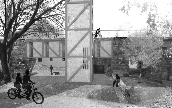
View of the project-Petr-Tuma-has-created-with-VisualARQ
In this section, we usually present projects performed with
Rhino by reputed architectural studies. But in the past of every great architect there is a young student who enrolls his name on the long list of his predecessors and show, for the first time, his vision. They don’t have a team in whom to delegate calculations and designs, makes a solo work and, from this page, we want to present his way of looking.
Today we contemplate the project created with
VisualARQ by
Petr Tuma, from the Czech Republic. We’ll see how the architecture, more than ever, is linked to urban planning since it develops a plan that gives new life to a city choke smothered by mining operations.
There is a project to expand the coal mines territory, which would mean the destruction of several towns, among them is
Horní Jiřetín.
Among the initiatives and plans to prevent this from happening, we find the work we present today which proposes an architectural and urban intervention to develop new links between its inhabitants.
The project revolves around two abandoned or destroyed enclaves which transforms them and endows them with new features:
- The disused railroad that crossed the town and connected it to a larger city where most of the population works. Now, this linear element has been recovered to create a bike trail. Thus, its use as a means of communication is restored without using motor vehicles.
- The space occupied by an old viaduct in the city center. In the project, it becomes a connection point between the different heights of the lower square and the upper road.
To both elements,
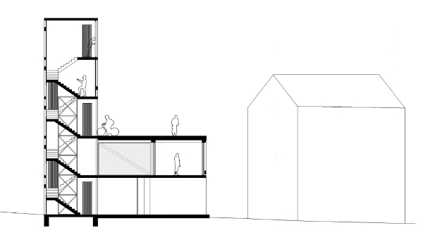
a five stories-high tower is added. In the second floor there is a meeting place for the community or for a cafe, which occupies the space between two of the ancient pillars that supported the viaduct.
The third floor is accessed via the bike trail and, if you want to see the mines whose exploitation threatens the city, you can do from the fifth floor.

Cross section of the project that Petr Tuma has created with VisualARQ for the city of Horní Jiřetín
This project does not start with a vacant lot where everything is possible. Here, the ancient elements that characterized the city are reused and given a new life.
In previous articles we have exposed the use of some of the VisualARQ features, as the
Level Manager, the
2D sections or Plan views o the
documentation tools but the advantage stressed by Petr Tuma is another:
the speed. He points out that with VisualARQ he can make multiple variations in Rhino without having to export the data to another program, combining BIM techniques with the free form modeling tools. “It saved me a lot of time in the edition of each proposal”, he tells us.
Thank you, Petr, for sharing your experience as a user of VisualARQ. You can see the full project in our
image gallery.
This is the advantage he stands out, what’s yours? And how did you used it in your project? We’d love to see your work, we wait for you in
Facebook.
Project description and images provided by Petr Tuma.
(Article by M.A. Núñez)


